Tag: google maps

  • Google Maps adds another nifty feature for Android and iOS users

    Google Maps adds another nifty feature for Android and iOS users

    Google Maps has already become a trusty companion for many Android and iOS users as the app is no longer just helps them navigate busy traffic. Less than a week ago, Google announced that Maps will be able to monitor air quality across the United States so that you can plan your outdoor activities accordingly.

    We’re pretty sure many more new features that might not have something to do with navigation will be added to the app, but the most recent one will definitely help you fully focus on your driving without having to think about … tolls.

    Starting today, Google Maps will show toll pass prices on both Android and iOS platforms. It’s a nifty feature that will allow users to choose which road to take, either it’s going to be the shorter route needing a toll pass, or the longer road that won’t cost you a dime.

    According to Google, the new feature will display the estimated toll price to your destination before you even start driving, which is possible thanks to the company’s partnership with local tolling authorities. The algorithm that presents you with the road choices and toll prices factors different variables such as having a toll pass or not, what the day of the week it is, as well as how much the toll is expected to cost at the specific time you’ll be crossing it.

    More importantly, the new feature comes with a toggle within settings that will allow users to make it show toll prices with or without having a toll pass, since the price changes based on the payment method you use in many regions.

    Also, Google Maps users will retain the ability to avoid routes crossing toll road completely, if possible, by choosing the “Avoid tolls” option within settings.

    As far as availability goes, Google announced that Maps users on Android and iOS should start seeing toll prices for about 2,000 toll roads in the United States, India, Japan, and Indonesia. It’s probably not much, but Google said more countries will be added in the not-so-distant future.

  • After update, Google Maps disappears from Android Auto

    After update, Google Maps disappears from Android Auto

    Google Maps helps users get from point “A” to point “B” using the most environmental-friendly and fastest route. And once you get to “B,” the app helps you find a place to eat, a place to sleep, things to see, and more. In other words, many travelers depend on the app and use it almost every day to help them make their daily commute without running into traffic jams, accidents, and speed traps.

    According to several posts made on Google’s support forums, after the latest update to Android Auto 7.2, Google Maps just upped and disappeared. The app still shows up on the user’s handset and can still be accessed as long as the car is not connected to the phone. Outside of an Android Auto community specialist, Google has yet to acknowledge that this problem exists and with that in mind, the search giant has yet to issue a workaround.

    There is a solution, however, users with this problem can switch to another navigation and mapping app like Waze. Also owned by Google, Waze uses crowdsourced data to help it deliver the fastest and safest routes for users to follow. Unlike Google Maps, Waze concentrates on navigation although it can still lead you to gas stations and restaurants. Or, if using Google Maps is a must, just run the app through your phone instead of using Android Auto.

    One user who posted on Google’s forum said that prior to the latest Android Auto update, everything worked perfectly on his 2018 Audi Q7 and his Samsung S21 Ultra. Once he installed the update, Android Auto no longer appeared as an app on his phone home screen and could not be reinstalled. The Q7 display no longer includes Maps; after using his voice to call for the Google Maps app, he is told that “This application is not available on your device.”

    While he can navigate using Google Maps on his Galaxy S21 Ultra, his car no longer displays maps and the turn-by-turn directions can not be heard from his car’s speaker. After talking with Samsung, the man says that he was told that the issue is not with his Galaxy S handset, but with Android Auto.

    In his post, he notes that he tried uninstalling and reinstalling updates, rebooting the phone, and re-setup Android Auto on his car, all to no avail. A subsequent post was sent in by a person with a similar story who uses a Galaxy S20 Ultra running Android 12. This person also lost Google Maps on Android Auto.

    The aforementioned community specialist with the Android Auto team responded by saying, “Thanks for reporting this issue. We have reached out to you via email to collect more information. Please share the required details.” So at this point, we have to assume that Google is not totally familiar with the issue.

    If you are affected by this bug,, you should simply use Google Maps on your handset, or switch to Waze on Android Auto. Either way, you will need to wait for Google to make the necessary repair through an OTA software update.

    Speaking of updates, Android Auto 7.2, the one that caused Google Maps to disappear, was released at the beginning of this year with no changelist.

    Have any of you found that Google Maps has disappeared from your Android Auto screen after installing the 7.2 update? If so, which one of our suggestions are you using? Did you decide to simply turn to your phone to run Google Maps, or are you continuing to use Android Auto and have switched to Waze. Let us know by dropping your comment in the box below.

  • New Google Maps widgets now available for iPhone

    New Google Maps widgets now available for iPhone

    For years, some iPhone users were jealous of their Android toting friends because of the lack of widgets on iOS. This ended with iOS 14 when Apple introduced its own Home Screen widgets at last. Many feel that the iOS implementation tops Android’s widgets. And while Apple Maps has its own iOS widget available, Google Maps is now offering two that require the installation of version 5.74 of the app on iPhone units running iOS 14 and up and iPad models with the iPadOS 15 beta download.
    Keep in mind that these Google Map widgets should not be confused with certain widgets found on the iOS widgets page such as Travel Times, Transit Departures, Local Guides and Traffic. A pair of Google Maps widgets is now available for the iOS Home Screen. The two widgets include one that is called “Find places nearby” and uses a search bar similar to Google’s iOS Gmail and Search widgets.
    This widget gives you shortcuts for quick directions “Home” and to “Work.” And with the widget, you can quickly get directions to Restaurants, Gas, Groceries, and Coffee purveyors in your current area.
    The second iOS Google Maps widget is called “Know before you go” and includes the latest traffic conditions, location details, times that stores open, reviews of restaurants, and more. This widget is a 1×1 square showing your current location with the traffic overlay on top.  And Google hinted in the release notes that more Maps-related widgets are coming. “In this release, we’re launching our first set of Home Screen Widgets to help you plan and navigate to your destination.”
    To install the widgets, press and hold on empty Home Screen space. Tap the “+” button in the upper left-hand corner and select Google Maps widget. If the widgets don’t show up, you might want to uninstall Google Maps and reinstall the latest version from the App Store.
  • New patch for Google Maps on CarPlay addresses annoying issue

    New patch for Google Maps on CarPlay addresses annoying issue

    If you own an iOS device and use any Google apps on it, you are probably no stranger to them being less optimized and maintained than their Android counterparts. One of the more recent cases was a particular bug in the Google Maps app where your chosen route would not show up on the screen when using CarPlay.

    The issue was first spotted during February this year in Google Maps for Android Auto. Many users reported that the blue line highlighting their chosen route had disappeared. The only indicators that remained were the guiding white arrows and the audio.

    Thankfully, the search giant acted somewhat quickly, and after a few weeks, the issue was resolved for Android Auto users. However, almost as an infectious disease in the code, the problem migrated to the CarPlay app for iPhone.

    In the middle of June, Google released patch 5.71 for Maps on CarPlay, partially taking care of the missing blue line issue. Now with patch 5.72, the problem seems to have disappeared entirely. This statement comes purely from users’ feedback, as Google has made no official comment on it.

    Apart from the missing blue line, some had also been reporting inconsistency in the GPS tracking of the app. Simply put, Maps would randomly stop following your location, almost as if it gave up. With the latest update, this issue looks to have gotten resolved, and the app no longer loses the person’s location.

    For those of you out there who are not sure which version of Google Maps you have, here’s how you can find out:

    1. Open Google Maps
    2. Tap on your profile at the top right
    3. Select Settings
    4. Tap on About, terms and privacy
    If you don’t yet have the latest update, just tap on the option in the App Store to manually search for it.
  • Google Maps makes paying for parking a snap in over 400 U.S. cities

    Google Maps makes paying for parking a snap in over 400 U.S. cities

    Has any app become as useful as Google Maps has become over the years? Every time you turn around, Google has added a new feature. And now, Google Maps users will be able to pay for parking and train tickets directly from the app. If an event runs longer than expected, you can add time to your meter without having to run out of the venue in the cold, driving rain, or miss the game-winning play or the show-stopping number just to feed the meter. You can also avoid touching parking meters, some of which could be lousy with coronavirus.

    Here’s how it works. As you approach your destination (which you’re tracking on Google Maps), the app will show a button that reads “Pay for Parking.” Enter the meter number, the amount of time you want to park there, and tap on pay. Pay for parking starts today with the Google Map app on Android phones in over 400 cities including Boston, Cincinnati, Houston, Los Angeles, New York, Washington D.C, and more. The feature will be coming to iOS soon and is driven by the Passport and ParkMobile apps.

    If you’re looking for transit directions on Google Maps, you’ll see a button giving you the option to pay for public transportation using the credit or debit cards connected to a Google Pay account. Google is adding the ability to pay transit fares from Google Maps for 80 transit agencies around the world. As Google says, “Now you’ll be able to plan your trip, buy your fare, and start riding without needing to toggle between multiple apps. You can understand how to pay in advance and even get your fare ready to go before you arrive at the station – which is helpful when you’re not sure what payment options a transit agency supports.

    When you get transit directions, you’ll see the option to pay with your phone with the credit or debit cards already linked to your Google Pay account. And in places like the San Francisco Bay Area, you’ll also be able to buy a digital Clipper card directly from Google Maps. Once you’ve purchased your fare, all you need to do is tap your phone on the reader or show your digital ticket to breeze on board.” Google Maps’ expansion to 80 transit agencies for ticket payments will rollout on Android in a few weeks.

  • Google Maps Street View might soon allow users to upload their own photos of places and streets

    Google Maps Street View might soon allow users to upload their own photos of places and streets

    Google Maps is now one of the most popular navigation and exploration tools, and a new feature coming to its Google Street View might soon allow people to upload photos to make sure hardly reachable areas of streets or cities can be visible in Google Street View. The feature to upload images will be present in the standalone app Google Street View, which will allow you to use your smartphone to contribute to Google Maps.

    In the beginning, in order to be able to place you on a street in Google Maps, Google had cars that went about with big 360-degree cameras that took photos of the streets. This later helps anyone who needs more precise navigation or to get a feel of the streets in Google Maps and Google Street View to virtually place themselves in the middle of the street and look around.

    Now, to further this capability and make previous unavailable-for-visualization places accessible, Google’s Street View will have a feature that can use your smartphone to take photos of the place as you drive. Reddit user -J-G- spotted the feature in Google Street View Driving mode. Additionally, Google might need to use some image processing and software to merge the photos together for a 360-angle view.

    As expected, the app will blur faces and vehicle plates, protecting the privacy of everyone while at the same time providing more images and visualization to Google Street View in places unreachable for Google alone.

  • Google Maps’ coolest new feature becomes more useful to Android and iOS users

    Google Maps’ coolest new feature becomes more useful to Android and iOS users

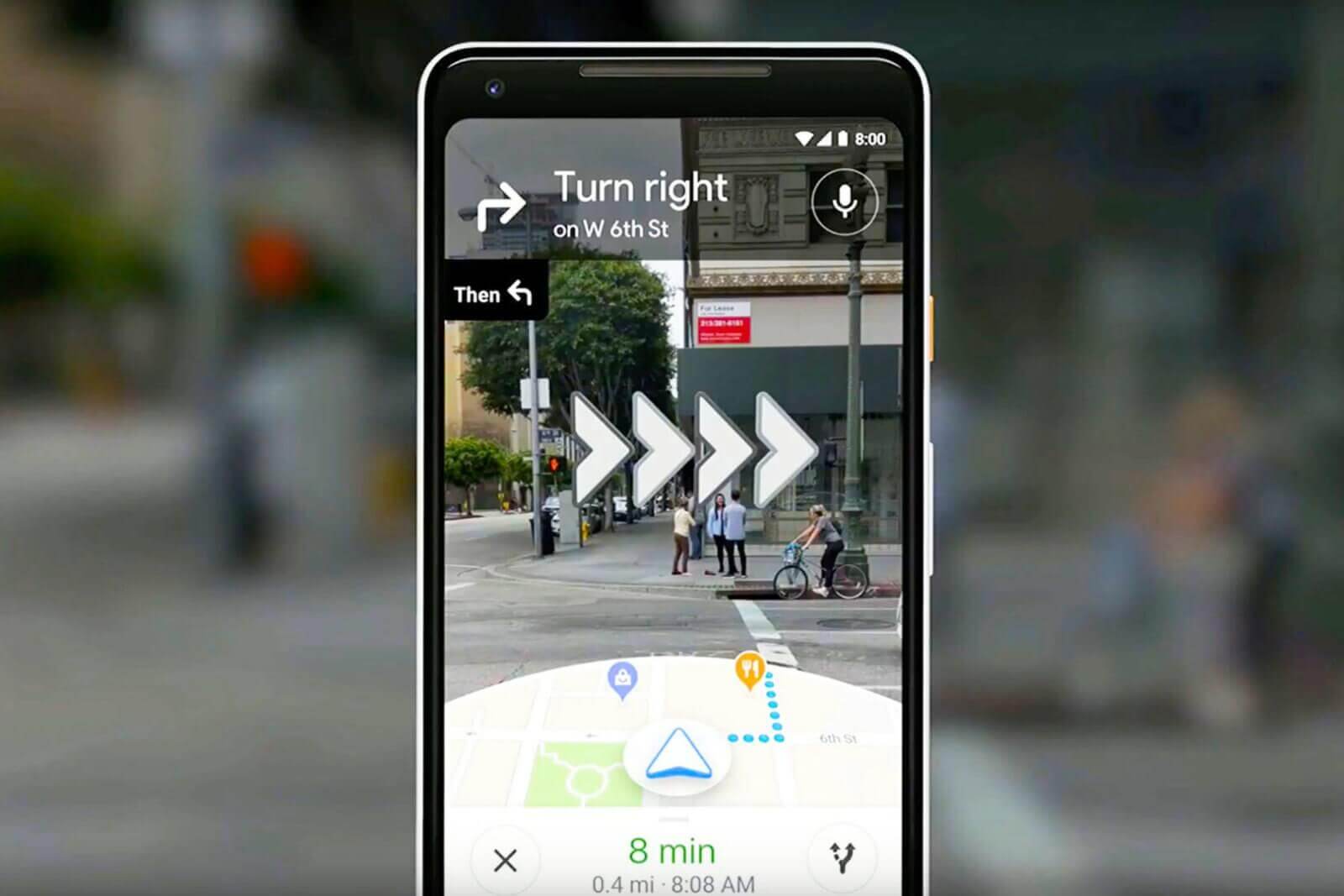
    Last year, Google Maps tested a beta version of what it calls AR Live Mode that uses augmented reality to layer the Maps UI over a real-time image from your phone’s front-facing camera. The result is the navigation for those-perhaps yourself-who enjoy getting around by walking around a city. The mode points out landmarks, how far they are from you, and how to get there. For example, if you’re walking through the Big Apple and happen to find yourself in Midtown Manhattan, you might see some information in AR Live Mode directing you to the Empire State Building.

    Google posted a blog today in which it says that the landmarks highlighted in Live View include well-known places, like local parks and tourist attractions. Besides the Empire State Building in New York, other noteworthy places include the Pantheon in Rome. 25 cities worldwide will soon have their Landmarks available to be viewed using Live View. Those cities include Amsterdam, Bangkok, Barcelona, Berlin, Budapest, Dubai, Florence, Istanbul, Kuala Lumpur, Kyoto, London, Los Angeles, Madrid, Milan, Munich, New York, Osaka, Paris, Prague, Rome, San Francisco, Sydney, Tokyo, and Vienna.

    Live View can be accessed by tapping on the button of the same name when looking up a place on Google Maps. It now can be used on the transit tab if part of your journey includes walking. Google points out that this is useful when you exit a transit station but don’t know which way to go once out of the station.

    Google also announced today that the Live View feature that previously was added to Location Sharing for Pixel users will soon be available to all Android and iOS users worldwide. Google explained this in today’s blog by noting that if a friend has chosen to share their location, you can tap on his icon and then on Live View to see where and how far away he is. Overlaid arrows and other directions make it easy to figure out how to get to where your friend is.

    Lastly, in Live View, using Machine Learning and Google’s understanding of the world’s topography, Google can more accurately place a destination pin. In the accompanying images, you can see how much closer Lombard Street in San Francisco appears when using Live View.

  • Google adds a COVID-19 layer to Google Maps

    Google adds a COVID-19 layer to Google Maps

    Google continues to work on improving Google Maps and on Wednesday a “COVID-19 layer” started rolling out. With this layer, users can see areas where the virus is spreading and it is coded by color based on the number of people with the coronavirus in each region. The layer produces these color codes based on the seven-day average for the number of new COVID-19 cases per 100,000 people and even reveals whether the number of cases is trending higher or lower.

    Google said that over a billion people rely on Google Maps to help them safely get from point “A” to point “B.” And that includes safely navigating around the virus by using the COVID-19 layer. As Google says, “This week, we’re introducing the COVID layer in Maps, a tool that shows critical information about COVID-19 cases in an area so you can make more informed decisions about where to go and what to do.”

    When you open Google Maps, tap on the layers button in the upper right corner of the screen and click on “COVID-19 info.” You will then see the seven-day average of new COVID cases per 100,000 people for the area of the map you’re looking at. The color-coding also reveals the density of new cases in the area. The COVID-19 layer starts rolling out on iOS and Android phones this week.

    The source of the data that you’ll see comes from legitimate places such as Johns Hopkins, the New York Times, and Wikipedia. Those places get their info from the World Health Organization, state and local health agencies, government organizations, and hospitals. And while consumers can get the same info through Google Search, they can also obtain it from Google Maps. As Google says, “While getting around is more complicated these days, our hope is that these Google Maps features will help you get where you need to be as safely and efficiently as possible.”

  • Google Maps continues to stay a step ahead of the crowd

    Google Maps continues to stay a step ahead of the crowd

    Google uses historical traffic data with Google Maps to help it produce an estimated time of arrival (ETA). This allows a user to see what time he should arrive at his destination. The ETA can also be shared with friends or family so that the user won’t have to pick up his phone while driving to pass along the information. But we don’t have to tell you that there have been changes in traffic patterns over the last few months because of the pandemic which led many cities to shutdown. When cities starting closing earlier this year, worldwide traffic declined by as much as 50%.

    The lockdowns led to a situation where data from Google Maps could not be relied upon, forcing Google to revise traffic patterns.  To account for the effects of COVID-19 on Google Maps, the apps prioritize more recent traffic patterns from the last two to four weeks while deprioritizing patterns from any time before that.

    Last week, Google published a blog post that discusses how the company computes traffic and routing on the Maps app. Location data is aggregated and used as a tool to determine what the traffic is like on roads around the world. As Google points out, this information is great at determining current driving conditions but doesn’t explain what will happen to traffic “10, 20, or even 50 minutes into your journey.”

    To guess what will happen in the future, Google Maps analyses traffic patterns on specific roads. For example, one pattern shows that the 280 freeway in Northern California typically has vehicles traveling at 65mph between 6-7 am, but only at 15-20mph during the late afternoon. Google combines the data from historical traffic patterns with the data from live traffic conditions. Using machine learning on both sets of data, Google generates an estimate of an estimated time of arrival.

    Google says that on 97% of trips using the Maps app, its predictions have been accurate. Partnering with parent company Alphabet’s DeepMind AI research lab, Google can reduce the number of inaccurate ETA’s through the use of Graph Neural Networks. Available in places like Berlin, Jakarta, São Paulo, Sydney, Tokyo, and Washington D.C., the technology allows Maps to predict whether you will be caught in a slowdown that hasn’t even started yet.

    To help the app pick the route that you should take, different factors are looked at including the amount of traffic along the way; less traffic is preferred of course. Road quality is also important; is the road paved or is it a gravel-covered road that is hard to drive on. Other drivers can report things like the weather (snowstorm, torrential showers, etc.), accidents, construction, and police activity that can slow things down.

    Have you ever used Google Maps to get directions to a place that you’ve been to many times before, but noticed that the app is taking you a different way? That’s because Google will find a new route if the usual one includes delays. Google describes what happens: “Say you’re heading to a doctor’s appointment across town, driving down the road you typically take to get there.

    When you leave the house, traffic is flowing freely, with zero indication of any disruptions along the way. With Google Maps’ traffic predictions combined with live traffic conditions, we let you know that if you continue down your current route, there’s a good chance you’ll get stuck in unexpected gridlock traffic about 30 minutes into your ride—which would mean missing your appointment. As a result, Google Maps automatically reroutes you using its knowledge about nearby road conditions and incidents—helping you avoid the jam altogether and get to your appointment on time.”

  • Google Maps can more accurately hone in on your location if you follow these directions

    Google Maps can more accurately hone in on your location if you follow these directions

    Google Maps’ Live View feature provides AR-based navigation to those who are walking from point “A” to point “B.” Over a real-time view of the streets ahead of you supplied by the rear cameras on your phone, directions and arrows are overlayed making it easy to walk from place to place. But there is another use for Live View AR. There are some areas where Google says that GPS won’t work perfectly, such as urban environments. ?Tall buildings in these environments create interference.

    If your GPS is disoriented, your phone’s camera and Street View data can help Google Maps figure out where you are. Tapping on the blue dot on Google Maps brings up a menu with options such as Share your location; Add a missing place; Set as parking location; Download offline map, and if you have the latest version of the app there will be a Calibrate with Live View option. Press on it and you’ll be taken to the Camera UI used by Live View. Point your camera at buildings and signs across the street from you and Google will hone in on your location after a short bit of panning.

    After you follow these steps, the blue dot will more accurately represent your current location. The beam that you see around the blue dot that shows you the direction that you’re heading will get narrower indicating that Maps has a better idea of where you are.

    The Calibrate with Live View feature has been found on Android phones that support ARCore. At the same time, the phone should be running the most up-to-date beta or stable version of Google Maps.

  • Google Maps Adds Plug Type Filter For EV Charging Stations

    Google Maps Adds Plug Type Filter For EV Charging Stations

    Google Maps has received a new filter to classify the Electronic Vehicles (EV) charging stations based on plug type. There are different types of charging connectors used by several car manufacturers, for example, Nissan uses CHAdeMO, Tesla uses its instrumentation, and also the BMW and VW use CCS plug kind for charging their cars. Since the emergence of the EV search facility over Google Maps, the users were missing out on the ability to filter results based on the connector type, GizmoChina reported on Sunday.

    The recent update will surely a sigh of relief for the daily drivers, it will facilitate them to drive car on to the compatible charging station. To use the new feature, the users can head over to the Google Maps > Settings > Electric Vehicle Settings >Your Plugs > Choose and save.

    Google Maps has recently revealed that it has captured more than 10 million miles of Street View imagery – a distance that could circle the globe over 400 times. The company also announced that Google Earth now lets people browse more than 36 million square miles of high definition satellite images from various providers – covering more than 98 percent of the entire population – to see the world from above.

  • Google Maps AR navigation is rolling out in beta on Android and iOS

    Google Maps AR navigation is rolling out in beta on Android and iOS

    Google Maps Live View—a new AR navigation mode that uses imagery from your phone’s camera—will be rolling out in beta on Android and iOS in the coming weeks. Live View takes advantage of your phone’s camera and Google Maps’ vast database to deliver a unique AR (augmented reality) navigation experience that layers the Maps interface over a real-time feed from the camera. It was previously demoed last year, and has been available to Google Local Guides level 5 and up, as well as Pixel phone owners, but it’s about te see a broader release later this month.

    To use Google Maps Live View, you’ll need a phone that supports ARKit, in the case of iPhones, and ARCore, in the case of Android devices. Of course, Live View is also going to be available only in regions where Street View is available, TechCrunch reports.

    To use Live View, you’ll need to tap the “Start AR” button and hold up your phone like a viewfinder. This brings up a screen that’s quite reminiscent of a video game, in that you’ll see the world around you, but with virtual elements (like arrows and signs) layered over your surroundings.

    To pinpoint your coordinates, Maps uses your phone’s rough GPS location and Street View’s vast image database to determine exactly where you are. To achieve this, the app takes a series of images, which have a known location, and analyzes them for key visual features (like the outlines of buildings and bridges), in order to create a large-scale index of these features. Then, to localize you, the system compares features in the database to imagery from the live camera feed. Using machine learning, it is able to discern between transient features, such as dynamic lighting and construction work, and the permanent features of the scene.

    Google warns that using Live View in Maps will lead to slightly increased battery and mobile data consumption. The feature is expected to roll out in beta on Android and iOS in the coming weeks.

  • Google Maps is getting new features

    Google Maps is getting new features

    Over the past couple of years, software and technology have become considerably more aware of the user. This extends from using biometrics to unlock your phone, to having your vitals regularly checked by a smartwatch on your wrist, to getting pestered by a digital well-being assistant. Health monitoring as a whole has proven to be potentially life-saving many times on an individual scale. But what about large groups of people, possibly the populations of entire cities, who may be at risk?

    Google Maps already provides relevant information during times of crisis with SOS alerts. These include real-time updates on the situation, a map of the affected area, emergency contact information, and translations for common phrases in the local language. With the latest update to Maps, SOS alerts are expanding with more detailed visuals and a new crisis navigation system will try its best to get you—and potentially hundreds, if not thousands of others—out of harm’s way.

    For example, in the case of a hurricane, you’ll automatically get a crisis notification card on Google Maps in the days leading to the expected disaster. The map will also display the predicted trajectory of the storm, alongside times when the hurricane is expected to hit certain areas in your vicinity. If you happen to be driving through an affected region on the day of the storm, you’ll get a suggestion for a safer route alternative. Such suggestions will be offered for all types of disasters while driving, starting later this summer.

    In the case of an earthquake, the crisis notification card will display a shakemap, which is a visualization of the earthquake’s epicenter, magnitude, and how surrounding areas were affected. Flood forecasts will notify you of possible floods, as well as where they are likely to occur, and where the waters are expected to flow. Google says this is especially important in regions like India, where over 20 percent of global flood-related fatalities occur.

    The revamped SOS alerts system will start rolling out to Android, iOS, and the web version of Google Maps in the coming weeks. Flood visualizations will first launch in Patna, India, and will spread to neighboring regions, and eventually globally, though curiously they won’t be coming to iOS, at least initially.

  • Google Launches New Products and Services for Indonesia

    Google Launches New Products and Services for Indonesia

    American technology giant Google announced a slew of new products and services that promise to benefit Indonesia’s rapidly growing digital economy.

    WizPhone 

    What surprised the audience most during the third annual “Google for Indonesia” event in Jakarta on Tuesday was the announcement of the WizPhone. The device, with styling reminiscent of the 1990’s, is the first Indonesian-made mobile phone equipped with Google Assistant, the tech giant’s artificial intelligence-powered virtual assistant.

    The WizPhone, which runs a lightweight mobile operating system known as KaiOS, will be sold at Alfamart convenience stores across Indonesia for only Rp 99,000 ($6.80).

    AI for Indonesian Translations 

    “More than half of online content is available in English, but only 1 percent of web content is available in Bahasa Indonesia,” said Ken Tokusei, director of international search at Google. This means that most internet content may not be accessible to some Indonesians.Tokusei said Google was working with Wikimedia to deploy a neural machine translation system that uses artificial intelligence to translate Wikipedia content from English to Bahasa Indonesia. Relevant search items that only used to be available in English will now also be available in Bahasa Indonesia, he said.

    Google Go

    With the use of artificial intelligence, the Google Go application can now be used to narrate articles on your favorite news websites, which is particularly handy if you are on the go. Just press “play” on any website and Google Go will read the text out loud to you in real time.This feature even works with a slower 2G connection as it is designed to use less data. The app is already available in Google Play and will also come preinstalled with all Android Oreo Go edition devices.

    “Our applications, such as YouTube-Go, Google-Go and Assistant-Go, have been designed to only use 50 percent of the phone memory compared with traditional applications,” Google Indonesia managing director Randy Mandrawan Jusuf said.

    New Features

    Bahasa Indonesia was added as an option in Google Assistant on all Android and iOS devices last April, which allows locals to set alarms or call people in their mother tongue. Scott Huffman, engineering lead for Google Assistant, said many people ask the application to tell them a joke to brighten up their day.One of the new features available in Google Assistant helps you book online transportation. You can tell it where you want to go and the digital assistant will open the Go-Jek or Grab app for you.

    This feature is currently only available in English, but Bahasa Indonesia will be added soon. Go-Jek Indonesia chief executive Nadiem Makarim said his company is looking forward to enabling Google Assistant to directly book rides without the need on to open the Go-Jek app.

    Another new future is a partnership with Indosat, Indonesia’s second-largest telecommunications service provider. Through Google Assistant, Indosat customers can now access their monthly bills and manage and monitor their quotas.

    A third new feature is the accessibility of news update, anywhere, anytime. All you need to do, is say, “listen to the news today,” and your digital assistant will do the rest.

    Advanced Google Maps Features

    Krish Vitaldevara, director of product management at Google Maps, said the navigation feature now has new options to make your daily commute easier. It allows you to follow public bus locations in real time. It also allows you to share the progress of your journey in real time, so if your bus is running late, you can keep your friends or family in the loop about your expected time of arrival. Google Assistant will even be there to remind you when to get off the bus.

    Business Application

    Google My Business is designed to help business owners connect with and attract more customers. Think of it as a social media platform for your business. Business entities now can make posts that will appear on their business profiles on Google Search and Maps, and share updates about products, offers and even events.It also allows customers to follow and interact with businesses.

    According to a Deloitte study, businesses can experience revenue growth of up to 80 percent by having an online presence. Based on this, Google has made it its mission to help Indonesian companies grow their online presence.

    “This country is full of determined and enthusiastic people; people who are ready to take over the world,” Randy said.