Retail News CRM

Tag: maps

  • New useful feature being tested for Android version of Google Maps

    New useful feature being tested for Android version of Google Maps

    Over the years we’ve watched as the Google Maps app has grown. Instead of just giving you turn-by-turn directions getting you from point “A” to point “B” safely and on-time, Google Maps now helps you decide what places you’ll visit and where you’ll dine when you arrive at “B.” And Google Maps has added several features related to driving. For example, the speed limit in the current area you are driving through now appears on the map, and accidents, speed traps, and other incidents can be reported so that other Google Maps users can benefit from your experience.

    Google is now testing the addition of traffic lights to the app. The icons for the traffic lights are small but appear larger while navigating. We should point out that Apple has added stop signs and traffic lights in Apple Maps. On iOS, Siri will point out both when you make a turn by one of them.

    The traffic lights were found by an Android user running Google Maps build 10.44.3. Frankly, we wouldn’t be surprised to see Apple and Google battle each other with their navigation apps. Apple has been working hard at removing the stench that spilled all over its Maps app when it was first launched in 2012. If you aren’t old enough to remember this fiasco, countries, and cities were mislabeled-when they were labeled at all. Police in Australia called Apple Maps “potentially life-threatening” when it navigated unsuspecting motorists to an area of the Outback with poisonous snakes, very little water, triple-digit temperatures, and spotty phone reception.

    Many iOS users still prefer to use Google Maps although we must let you know that the traffic lights are being tested on the Android version of the app only.

  • Google Maps update will help commuters plan their social distancing

    Google Maps update will help commuters plan their social distancing

    Google never stops working on several key apps. One of these is Google Maps which no longer is limited to turn-by-turn directions. Google Maps will also show you places to go and things to see wherever your travels take you. It also shows you more enhanced walking directions in AR and recently launched Maps’ “Plus Code” that allows users to share their precise location with friends and family

    Today, Google announced that the iOS and Android version of Maps will receive an update allowing users to discover in advance how crowded a train or bus is (a mobbed train or bus could raise the risk of catching COVID-19) or whether a bus or train is running on a limited schedule. Google says that essential workers need this information to get to their jobs and others will want this data too as more countries reopen.

    Last year Google added “crowdedness predictions” in Google Maps that used crowdsourced data from tens of millions of riders to help Google forecast how crowded a bus or train line would be at a certain time of day. Now, Google is making it easier for users to contribute to this data. Look up Directions, tap to see Transit Details, then scroll down to find crowdedness predictions where it is available. There, users can enter their own experiences.

    Starting today, you can use Google Maps to find the times historically when there are large crowds of people at a transit station. You can also see live data that compares current crowd size to usual conditions. This should help you plan your social distancing. To find this information, search for a transit station in Google Maps or tap on one when it appears on the screen. That will call up the departure board and busyness data (if available). This feature will be rolling out over the next several weeks and is based on aggregated and anonymized data from those who have opted into Google Location History. The latter is off by default. To keep the information anonymous, the busyness data is shared only when enough users are opting in to provide sufficient data.

    Maps is adding alerts from local transit agencies that will alert users if there are any COVID-19 related rules that affect commuters using mass transit such as whether masks are required when on trains or buses. These transit alerts are being pushed out now by Google in countries including Argentina, Australia, Belgium, Brazil, Colombia, France, India, Mexico, Netherlands, Spain, Thailand, United Kingdom, and the U.S. More countries will be added soon.

    Google is also adding notifications and alerts about any COVID-19 checkpoints and restrictions along your route. This will appear even when you’re driving across national borders starting with the U.S., Canada, and Mexico). If you’re driving to a medical facility or a COVID-19 testing center, Google will remind you to verify eligibility and facility guidelines so that you’re not turned away.

    Google says, “Getting from A to B can be more complicated these days. Because of COVID-19, it’s increasingly important to know how crowded a train station might be at a particular time or whether the bus is running on a limited schedule. Having this information before and during your trip is critical for both essential workers who need to safely navigate to work and will become more important for everyone as countries around the world begin to reopen. COVID-19 has certainly impacted the way that we move around in the world. As cities and countries across the globe adapt, we’re committed to bringing the most pertinent information right to your fingertips. So when you’re ready and able to, you can safely venture out.”

  • New Google Maps feature is designed for those who fear that they have been infected

    New Google Maps feature is designed for those who fear that they have been infected

    We often wonder whether Google has a room where it keeps several developers locked inside. Inside is a whiteboard and those locked inside cannot leave until a new feature is developed for Google Maps. The latest addition to the app is related to the current coronavirus pandemic. The Center for Disease Control (CDC) in the U.S. has recommended that anyone who feels that they are exhibiting symptoms of coronavirus call their doctor first before driving to the hospital. This might prevent users who aren’t ill from coming down with the dread disease. And it also could help to take some pressure off an already taxed hospital system.

    An update to Google Maps will now show a reminder when someone is using the app to search for a doctor or hospital. A rectangular box near the bottom of the screen has a heading that is printed in red to catch the attention of a Maps user. It says COVID-19 alert. Then, in black type, the message says “Call your doctor before visiting if you may have COVID-19. Source: CDC.”

    Google is also trying to pass along legitimate information to the public while blocking misinformation, speculation, and outright fraudulent reports from worried and scared people around the world. Go to the Google Search app and type in coronavirus and you’ll see four tabs: Overview, Symptoms, Prevention and Treatments. An overview will show you the latest news about the virus from reputable media organizations. Symptoms provide a rundown of COVID-19 symptoms from the World Health Organization (WHO) and also lists some top stories. Prevention mentions several tips that are supposed to keep users from contracting coronavirus, and Treatments explains that there currently are none for COVID-19.

    WhatsApp also is looking to inform users with information from a reliable source. Text “Hi” to +41 79 893 1892 on the app and you’ll receive some information about the coronavirus via text. Additionally, if you open your mobile browser and go to whatsapp.com/coronavirus, scroll down to the section with the heading “Choose reliable sources of information.” There you will find a link to the World Health Organization (WHO). If you have WhatsApp installed on your phone, clicking on the WHO link will open a chat platform. This might help users get a better grip on what really is happening on the front line. Keep in mind that the chat does not connect the user with an actual MD so the platform cannot be used for diagnostic purposes.

    The Director-General of the WHO, Dr. Tedros Adhanom Ghebreyesus, has nothing but praise for Facebook and its WhatsApp messaging app. The doctor says, “Digital technology gives us an unprecedented opportunity for vital health information to go viral and spread faster than the pandemic, helping us save lives and protect the vulnerable. We are proud to have partners like Facebook and WhatsApp, that are supporting us in reaching billions of people with important health information.”

    Facebook announced yesterday some other initiatives it is taking during this crisis. Number one on the list is to make sure that everyone has accurate information. That seems to be at the heart of everything that the company is doing when it comes to the coronavirus. Facebook is also removing posts with misinformation and harmful content including those that seek to exploit the crisis by touting fake cures or selling items in short supply for jacked-up prices. The social media company is supporting global health experts and relief efforts by making donations and giving reputable organizations free ads. And by promoting ways that people can connect via WhatsApp and making investments to small businesses, Facebook is supporting local governments, communities and businesses.

  • Google Maps gets a smart new feature perfect for travelers

    Google Maps gets a smart new feature perfect for travelers

    If you’re a frequent traveler who’s always looking for a new place to eat, you might really appreciate this subtle-but-powerful new feature baked into Google Maps.

    New to Google Maps is integration with Google Lens, the powerful image recognition system first introduced in 2017. With the latest update to Maps, the software will enhance listings for restaurants with more information on the menu.

    We already know how competent Google Lens is at identifying text and symbols in images, but this new feature will take things a step further with more information. When user-uploaded pictures include a shot of the menu, the software will kick in and give you more context to help you decide what to eat.

    The interface will give you the option to ‘Explore dishes’. It can identify the most popular items, find images for dishes, or even translate foreign menus to give you a better idea of what a dish will look like.

    The exciting thing about this is that it happens without any work from the restaurant’s end. As long as a reasonably clear photo of the menu exists in Google’s database, your phone should be able to generate these options and context information.

    As you might expect from how heavily it relies on Google services, the feature is only available on Android for now, but like most Maps features, it’ll likely make its way across to the iOS pond before too long.

  • Apple launches redesigned Maps app for users in the US

    Apple launches redesigned Maps app for users in the US

    Apple has just announced that Maps users in the United States now have access to a redesigned app that integrates a lot of social elements, but also important under-the-hood improvements. Apple’s new Maps app is faster and more accurate thanks to the many new features introduced by iOS 13 not long ago.

    In an attempt to compete with Google Maps, Apple’s own navigation app promises to offer extensive views of roads, buildings, parks, airports, and malls. Also, Maps now includes support for popular apps like Photos, Messages, Calendar, Weather and more.

    An important addition to the app is the new interactive street-level imagery with high-res, 3D photography that you can see above. This feature lets people from anywhere in the world virtually visit many US cities, including New York City, San Francisco, Los Angeles, Las Vegas, and Houston.

    As far as the social aspect goes, Maps now includes a new feature called Collections where users can share lists of their favorite restaurants, as well as places and locations they wish to visit. Furthermore, Maps lets commuters or users who frequently visit a certain location to add it to Favorites so that they bring it up on the screen with just one tap.

    It’s also worth noting that the app now includes indoor maps for airports and malls, along with an option to send an ETA to family or friends. More importantly, Apple Maps offers real-time information about transit schedules, live departure times, arrival times and so on. For the time being, real-time transit is not available in all US cities, but it’s up and running in San Franciso Bay Area, Washington D.C., New York, Los Angeles, and Miami.

    Apple says it will continue to improve Maps and that the newly redesigned app will be rolled out to customers in Europe in the coming months, so expect more news about it very soon.

  • Update to Google Maps solves issue with gesture navigation

    Update to Google Maps solves issue with gesture navigation

    One thing that Android users are appreciative of is Google’s desire to keep tinkering with its apps. And once again, it is Google Maps that is the beneficiary of the latest update to come from Mountain View. The new Maps UI eliminates the side menu. Swiping to the right from the left edge will also no longer bring up the side menu, which is a boon to those who use gesture navigation on Android 10. That’s because opening the side menu can accidentally trigger the “back” gesture on the latest Android build. And the three-bar hamburger menu no longer appears on the left side of the search bar.
    The three tabs found on the bottom of Google Maps (Explore, Commute, For you) now number five and include Map, Commute, Saved, Post and Latest. Once your Google Maps app has been updated to the new UI (and it hasn’t yet on our Pixel 2 XL running Android 10), you can find the settings and some of the other options that were on the side menu by tapping on your avatar. A box will open that allows you to switch the account linked with the app, enable incognito mode (so that your travels and location searches won’t be recorded by Google), view the app’s settings and more.
    The latest version of the Google Maps app is 10.31.2, but even if you have just updated the app (as we did right as we started writing this article), there is no guarantee that the new UI will appear. Nope, you are going to have to wait since this is a server-side update that cannot be triggered by Android users.
  • Google Maps’ incognito mode now available for iOS users

    Google Maps’ incognito mode now available for iOS users

    You might recall that back in October, Google disseminated an update that added incognito mode to the Android version of Google Maps. First, we do need to get something straight for all of you philanderers our there. This mode doesn’t allow you to travel to your weekly rendezvous sight unseen as though you were wearing Harry Potter’s “Cloak of Invisibility.” Instead, when Maps’ incognito mode is enabled, searches made on the app and places you navigate to are blocked from being added to your Google account. As a result, you won’t receive any personalized recommendations in the Maps app (like places to dine) and your Location History will not be updated. Today, Google has announced that this feature is now available on the iOS version of Google Maps.

    In addition, Google points out that a new feature called bulk delete will be coming to Android users next month; this will allow them to find and delete multiple places from their Timeline and Location History in one fell swoop. But Google wants you to make sure that you know what you’ll be missing by not allowing it to keep your Location History. If you use incognito mode or delete Location History, you won’t be able to see wait times at restaurants and grocery stores (which is computed using “aggregated and anonymized Location History information”). You also won’t be able to see previews of the parking situation at your destination, be given a time-to-leave alert, use “Your Match” to calculate how much you might enjoy a particular eatery and use the Explore tab to find nearby coffee shops, parks restaurants and more.

    Lastly, Google is adding a much needed new feature to the Android version of the Google Opinion Rewards app. The app allows you to build up Play Store credit by answering survey questions. Depending on what is being asked, users can score 10 cents to nearly $1 each time they participate. The credit must be used within a year, something that not every user knew. Recently, there were some complaints about credits disappearing from the app after they had expired. To make sure that users don’t waste any credits, an expiration date for the oldest credit will now appear underneath the account owner’s current balance.

    We’ve used the app during the year and all it takes is a few seconds of your time. And the credit can be used to purchase videos, books, apps and to make in-app purchases. Android users can install the app from this link. Because Google Play Store credits would be useless to iOS users, this version of the app pays out in small cash credits that are deposited into a PayPal account.

  • Google Maps update adds a new translator feature

    Google Maps update adds a new translator feature

    The new translator feature that will be added this month should allow a phone to speak out a place’s name and address in the local lingo. In order to do that, you’ll have to tap the new speaker button next to the place name or address, and Google Maps should then say it out loud.

    In addition, Google Maps will be able to link you to the Google Translate app when you need to have a more complex conversation. Thanks to the text-to-speech technology, your phone automatically detects what language your phone is using to determine what exactly you need help translating.

    According to Google, the new translator feature will be deployed to Android and iOS devices this month and will support 50 languages, although the Mountain View company says that more are on the way.

  • Google Maps update will help you find historical landmarks in major cities

    Google Maps update will help you find historical landmarks in major cities

    We’re thinking that the Google Maps team is fueled by pots and pots of coffee. How else can you explain the number of new features that are added to the app? Developers must pull 24-hour shifts a few days a week and we envision a whiteboard filled with multiple ideas. The latest addition to Google Maps, allows users to quickly find major landmarks in big cities. Note the words “major” and “big.” In other words, you’re not going to see one of these large icons appearing on a map of a one-horse town to show you where the local Dairy Queen is.

    On the other hand, as you can see from the screenshots accompanying this article, the Brooklyn Bridge in New York City, Big Ben, Buckingham Palace and Westminster Abby in London and the Arc de Triomphe and Eiffel Tower in Paris do feature the larger icon. It appears that Google is placing these easier to spot icons next to older landmarks that have a history behind them. Interestingly, the White House doesn’t merit one of the larger icons although New York’s Rockefeller Center does. Whether Google is currently in the process of adding new landmarks is unknown, but it would be interesting to know what the company’s criteria are. We have reached out to Google for more details, and if they respond we will update this story.

  • Google Maps updated with new ways to report driving incidents

    Google Maps updated with new ways to report driving incidents

    Google has just announced that a new update is making its way to the Maps app on mobile. The update brings new ways for Google Maps users to report driving incidents and will be available globally starting this week.

    The most important change included in the update is the addition of a new ability that allows Maps users to report crashes, speed traps, and traffic slowdowns directly from their iPhones. The same features proved to be extremely popular among Android users, which is why Google has decided to bring it to iOS as well.

    The next major improvement is the ability to report four new types of incidents: construction, lane closure, disabled vehicles, as well as objects on the road. The new option lets Maps users know whether or not they’ll encounter one of these obstructions on their ride.

    If you stumble upon such an obstruction, the easiest way to reports with the new version of Google Maps is to simply tap on the + sign and then on “Add a report.” The update revealed today by Google will be rolled out globally on Android and iOS starting this week.

  • Google Maps’ Incognito Mode is being tested for those who don’t want their whereabouts known

    Google Maps’ Incognito Mode is being tested for those who don’t want their whereabouts known

    Google Chrome has an Incognito Mode that allows users to browse the web privately. Even someone else that you might share the same device with won’t be able to discover that you’ve been checking out the latest news about the Google Pixel 4 because you plan on pre-ordering one. Not only will your browsing history be protected from prying eyes, but any forms that you fill out while incognito will also remain private. To go incognito on Chrome, tap on the three-button overflow menu on the right-hand corner of the screen. Go to Settings > New incognito tab. You can tell you’re in this mode when you see the Walter White like image of a man wearing hat and glasses to the left of the web address.
    Believe it or not, YouTube also offers an Incognito Mode. To activate it, open up the YouTube app and tap on your profile picture in the upper right-hand corner of the screen. Click on Turn on Incognito. With the Mode on, your Boston Red Sox-loving’ girlfriend will never know that you’ve just watched highlights of the recent New York Yankee game. Or when your conservative father-in-law borrows your phone, he won’t be able to notice that you’ve been watching Stephen Colbert clips every night. When the man wearing hat and glasses appears where your profile picture normally shows up, you know that you’re in Incognito Mode.
    Now, Google is testing an Incognito Mode for Google Maps. This would allow you to search for directions to a place that you don’t want anyone to know you’ve visited. Those who are part of the test group received an email today from Google. If you are one of the lucky ones who were able to update to the preview of Maps version 10.26, open the app and tap on the profile picture which is-wait for it-in the upper right-hand corner of the screen. Select “Turn on Incognito mode.” You’ll notice that the locator marker will turn colors from blue to a dark gray.
    If you’re not part of the test group, you might have to wait a few weeks for Google to disseminate this feature to all eligible Android users. Until then, anyone you share your phone with can look at the addresses you’ve looked up directions for.
  • Just google Amazon fire

    Just google Amazon fire

    The rainforest is burning. So much so, that it can be seen from space and people are starting to get worried over the unprecedented forest fire spread, just like in Siberia or Alaska this year, which is shaping up to be the hottest on record.

    The thing with Brazil’s rainforest, however, is that it not only gobbles vast amounts of greenhouse gases, but also serves as a vast cloud highway that helps maintain the global climate balance. You’ll hear varying opinions on the level of disaster in our divided society – either that July and August are the typical forest fire months and the intensity is actually below average, or that the scale is unprecedented, and 85% higher than last year.

    In any case, we are not here to argue about climate change but to note one amusing fact that happened around South America’s fires. The most famous natural wonder there is undoubtedly the amazonian rainforest, so, naturally, people who were interested to read more on the matter keyed into Google the words “Amazon fire” as one does.

    With Google, Facebook and Amazon occupying nearly 80% of the online advertising space and budgets, however, the first and subsequent search results were about the Amazon Fire tablet. The law of unintended consequences kicked in for Amazon, and it must have sold a boatload more of its budget slates than usual in this back-to-school month.

    Google quickly fixed that wrong, and when you search for Amazon fire now, that’s exactly what comes up as the first result – information about the flames running through the rainforest, as well as various musings whether they are caused by climate change.

    The Amazon Fire tablet and various Bezos-endorsed gadgets, however, are still strong in the news search as you can see from this current snippet below – oh, the world we live in!

  • Google Maps AR navigation is rolling out in beta on Android and iOS

    Google Maps AR navigation is rolling out in beta on Android and iOS

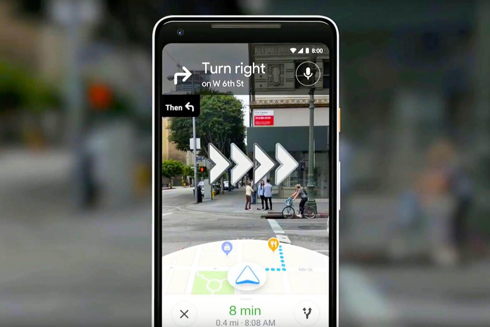
    Google Maps Live View—a new AR navigation mode that uses imagery from your phone’s camera—will be rolling out in beta on Android and iOS in the coming weeks. Live View takes advantage of your phone’s camera and Google Maps’ vast database to deliver a unique AR (augmented reality) navigation experience that layers the Maps interface over a real-time feed from the camera. It was previously demoed last year, and has been available to Google Local Guides level 5 and up, as well as Pixel phone owners, but it’s about te see a broader release later this month.

    To use Google Maps Live View, you’ll need a phone that supports ARKit, in the case of iPhones, and ARCore, in the case of Android devices. Of course, Live View is also going to be available only in regions where Street View is available, TechCrunch reports.

    To use Live View, you’ll need to tap the “Start AR” button and hold up your phone like a viewfinder. This brings up a screen that’s quite reminiscent of a video game, in that you’ll see the world around you, but with virtual elements (like arrows and signs) layered over your surroundings.

    To pinpoint your coordinates, Maps uses your phone’s rough GPS location and Street View’s vast image database to determine exactly where you are. To achieve this, the app takes a series of images, which have a known location, and analyzes them for key visual features (like the outlines of buildings and bridges), in order to create a large-scale index of these features. Then, to localize you, the system compares features in the database to imagery from the live camera feed. Using machine learning, it is able to discern between transient features, such as dynamic lighting and construction work, and the permanent features of the scene.

    Google warns that using Live View in Maps will lead to slightly increased battery and mobile data consumption. The feature is expected to roll out in beta on Android and iOS in the coming weeks.

  • Google Maps update brings two new important features for commuters

    Google Maps update brings two new important features for commuters

    Google launched two new features for Maps, which will greatly help those using public transportation to commute every day. The new features, live traffic delays for buses and crowdedness predictions, will help Google Maps users to plan better for their transit ride.

    Since transit schedules aren’t always accurate due to real-time traffic conditions, Google has decided to launch live traffic delays for buses, a new tool that will feed Maps users with real-time info directly from local transit agencies.

    It will allow Google Maps users in select cities to see if their bus will be late, how long the delay will be, as well as more accurate travel times based on live traffic conditions along their route. The new feature will be visible on the map too, as you’ll be able to see exactly where the delays are on the map so you know what to expect before you get your bus.

    The second new features announced today is transit crowdedness predictions, which will allow Maps users to see how crowded their bus, train or subway is likely to be based on past rides. That way you’ll be able to take a more informed decision when taking a bus or waiting for the next one to arrive.

    Starting today, both new features will be available in Google Maps in nearly 200 cities around the globe on both Android and iOS.

  • Google adds new Maps features that offer some users rewards and perks

    Google adds new Maps features that offer some users rewards and perks

    Google has just announced a new set of features for business owners that will allow them to give Maps users an incentive to follow and, eventually, buy from them. Five years after launching Google My Business, which supposedly helped more than 150 million local business connect with people who are looking for them online, Google has decided to evolve it by adding new features and brand new design for mobile.

    The most important changes are aimed at Maps users who will now be able to find a business much easier. For example, business owners can now claim a short name and URL for their business, and in the coming months, people will be able to search short names directly in Maps.

    Moreover, starting today, businesses will be allowed to reward customers who follow their business on Google Maps with welcome offers, including discounts and other rewards. To make their businesses more appealing to potential customers, Google introduced the option to set the preferred profile cover photo.

    Also, businesses will be able to add photo captions to their profiles, which will tell the stories behind the pictures. A new logo feature has been revealed as well, which will allow businesses that completed their core info to have their logo displayed at the top right-hand side of their profile.

    Maps is one of the first apps that gets these new features for businesses, but Google might bring some of them to other apps or devices like Assistant and smart speakers, which would be in line with the company’s voice strategy.